French electricity distribution network operator ERDF and Survey Copter, a subsidiary of Cassidian, have partnered to develop unmanned aerial vehicle (UAV) for the inspection of medium-high-voltage aerial power lines (20,000V).
UAVs will allow ERDF operators to collect directly usable data on the status of the networks, such as conductors and pylons, more regularly and at lower cost.
Discover B2B Marketing That Performs
Combine business intelligence and editorial excellence to reach engaged professionals across 36 leading media platforms.
In addition, they will allow the operators to visualise and model interference with vegetation, in order to schedule maintenance and tree-pruning operations.
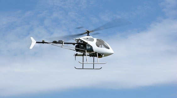
The partnership has been evaluated in the Drome and Ardèche départements and is expected to result in the deployment of a Survey Copter’s Copter 4 UAV during 2014.
The Copter 4, with an all-up weight of 30kg, offers a range of approximately 50km and can stay in the air for around two hours.
Cassidian stated that such missions are helpful especially in the event of major meteorological events or climatic hazards leading to fallen power lines.

US Tariffs are shifting - will you react or anticipate?
Don’t let policy changes catch you off guard. Stay proactive with real-time data and expert analysis.
By GlobalDataThe rapid detection and speed of diagnosis of the affected regions is a key element in restoring power, the company said.
Survey Copter’s DVF 2000 UAV allows prompt inspection of the aerial lines and identification of any damage, as well as the condition of the road infrastructure that provides access to the damaged lines.
This partnership is expected to lead to a rise in the number of automated operations for this type of mission, offering a solution that is technically and economically far more competitive.
ERDF deputy director for the Sillon Rhodanien region Claude Dubreuil said that rapidly obtaining extremely precise images of locations that are often inaccessible is a necessity for ERDF and this partnership would help fulfil this need.
"The purpose of the experiments currently under way is to validate the feasibility and economic conditions of this innovative technique," Dubreuil said.
Survey Copter CEO Jean-Marc Masenell added that the aim of the partnership with ERDF was to implement real industrial solutions that will be able to meet the need for inspection not only of the aerial lines, but also of other electricity production infrastructure.
"The variety of our UAVs and the sensors we can install on them means that we can address all these requirements," Masenell said.
"The roadmap we have established with ERDF will enable us to develop and then gradually deploy these solutions, involving other partners so that eventually a complete service can be provided, including not only data collection by the UAV, but also its post-processing and formatting."
Image: The ERDF and Survey Copter partnership is expected to result in the deployment of a Survey Copter’s Copter 4 UAV during the course of 2014. Photo: courtesy of Cassidian, an EADS Company.