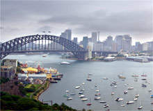
In Sydney it is called the fog season; the period between April and July when the harbour city wakes up to a blanket of fog so dense that only the tops of the skyscrapers and the bridge can be seen and the opera house disappears completely.
As picturesque as these white-outs may be, they lead to transport chaos. Ferries were cancelled, buses and cars slowed to a crawl and the airport shut down due to low visibility. In the case of the latter, having to divert to Melbourne, Canberra or Brisbane is not a lot of fun when you have just spent 20-plus hours on a 747 and you have a connection to make.
Fogs are caused by differential cooling between the ocean and the land. Relatively warm, moist airflows are driven by onshore winds onto the cooler land resulting in a pea-soup fog. The result is that hundreds of flights can be delayed during the six to ten hours each year that the Sydney Airport Corporation says fog renders the airport unusable. Melbourne suffers from about 40 fog hours at the same time of year and fog also causes issues with Canberra and Perth airports.
It is the pilot’s call, in consultation with the control tower, whether to divert, go around again or try to land; and 800m visibility when the aircraft is at 61m on final approach is the decision point. Planes that divert go to other airports, such as Brisbane, Melbourne and Canberra all an hour or so away which can disrupt flight schedules for hours. In May 2007, a United Airlines flight was delayed in Brisbane for nine hours waiting for the fog to lift in Sydney.
THE SOLUTION – INSTRUMENT LANDING SYSTEMS
This level of disruption costs airlines huge amounts of money – just how much no one is prepared to say – and it also causes passengers a great deal of inconvenience through missed connections and the extra time spent in the aircraft after a long flight.
How well do you really know your competitors?
Access the most comprehensive Company Profiles on the market, powered by GlobalData. Save hours of research. Gain competitive edge.

Thank you!
Your download email will arrive shortly
Not ready to buy yet? Download a free sample
We are confident about the unique quality of our Company Profiles. However, we want you to make the most beneficial decision for your business, so we offer a free sample that you can download by submitting the below form
By GlobalDataA Singapore Airlines spokesperson said that it is ‘just part of the business of aviation’, yet the technology to allow aeroplanes to land in low visibility is long established. The development of an instrument landing system (ILS) began in 1929, it was first used by a commercial airliner in 1938 and the six major US airports had ILS installed by 1941.
ILS is a ground-based system that uses a combination of radio signals and, in many cases, high-intensity lighting arrays to provide precision guidance to an aircraft on approach during conditions of reduced visibility such as fog. There are two fully independent parts to an ILS: the localiser provides lateral guidance while the glide slope or glide path (GP) system provides vertical guidance to ILS receivers in the aircraft.
Localiser antenna arrays consisting of several pairs of directional antennas are normally located beyond the departure end of the runway.
Two signals, at 90Hz and 150Hz, one slightly to the left of the runway centreline, the other to the right are transmitted on ILS channels from separate but co-located antennas which each transmit. The aircraft’s localiser receiver measures the difference in depth of modulation (DDM) which varies depending on the position of the approaching aircraft from the centreline.
The glide path antenna array is situated to one side of the runway touchdown zone and transmits a signal in a similar way to that of the localiser. Both signals are displayed in an omni-bearing or nav indicator on the instrument panel and some aircraft and systems are able to link to the autopilot which then flies the approach automatically.
While the technology has been steadily developed for the last 70 years, ILS has some disadvantages. Large buildings or hangars can obstruct the localiser and the terrain in front of the glide path antennas can also cause issues and because of the way the arrays are aligned they are only effective for straight line approaches. It is also expensive; for example, each ILS antenna array costs about A$1m. Sydney would require six arrays and Melbourne four, plus there is the cost of continuous maintenance and calibration work which is considerable.
THE NEXT GENERATION OF AIRCRAFT LANDING SYSTEMS
As a result, various aviation authorities have been working on the next generation of all-weather aircraft landing systems. During the 1970s, a microwave landing system (MLS) started to come into use at major airports in the United States and Europe but airlines were slow to adopt it because of the expense of changing to the new system.
In time, MLS technology was overtaken by the explosion in popularity of the global positioning system (GPS) which has led to the next evolutionary stage in landing systems, a local area augmentation system (LAAS) also known as ground-based augmentation system (GBAS).
The principals behind LAAS/GBAS are simple. At best, a standalone civilian GPS unit has an accuracy of about 15m. To boost accuracy to the level where it can be used for a precision approach LAAS/GBAS provides a real-time correction of the GPS signal through a group of precisely surveyed reference receivers. A signal received from the GPS constellation is compared to the surveyed locations and the aggregated data is used to calculate a correction which is transmitted to the aircraft over a VHF data link. A receiver on the aircraft corrects the GPS signals it is receiving and then creates a standard ILS-type display for landing.
LAAS/GBAS has several advantages but also a couple of disadvantages. One major advantage is that it handles curved approaches easily and the other is that it is comparatively cheap. A complete LAAS/GBAS system costs around A$1m and it can cover all airports within a 25nm radius.
In the Sydney and Melbourne context the one system would cover the main airports’ multiple runway approaches plus subsidiary airports such as Bankstown in Sydney and Essendon, Moorabbin and Avalon in Melbourne.
LAAS AND GBAS: THE DISADVANTAGES
Despite these major advantages there are also some disadvantages. LAAS/GBAS potentially has a single point of failure in that interference with or failure of the GPS system would disable it completely. The systems are also exclusively designed for aircraft and LAAS/GBAS-capable GPS receivers are priced around US$10,000 and upwards compared to around A$1,500 for a good general aviation GPS receiver.
The major disadvantage, however, is accuracy. An Air Services Australia spokesperson said that it could take up to ten years before LAAS/GBAS is certified to a Category IIID approach. This provides the capability for an aircraft to land in zero-visibility conditions using ‘hands-off’ auto land systems and requires an accuracy of less than 1m.
WHERE DOES THIS LEAVE PASSENGERS?
So where does that leave business people and tourists flying into Sydney, Melbourne, Canberra and Perth during the fog season? There is cause for some hope. Melbourne is currently installing the arrays and lighting systems required to take it to Category III ILS by the end of the year. The Civil Aviation Safety Authority (CASA) will be releasing a discussion paper later this year which is aimed to begin the process for Sydney, followed by Canberra then Perth, to be upgraded to Category III sometime in the future.
Requests for an interview with Sydney Airport Corporation were met with the dispatch of a ‘fact sheet’ stating, "The incidence of fog disruptions to services at Sydney Airport is very low. On average, Sydney Airport is impacted by fog for around six to ten hours a year – about 0.16% of the time. There have been some years when there have not been any fog disruptions at all.
"Sydney Airport is working with the aviation industry to maximise operations in low-visibility conditions and has upgraded facilities by installing transmissometers to provide pilots with more accurate electronically derived visibility information. This will maximise opportunities for departures in fog as well as assisting landings. Further upgrades are being coordinated with the aviation industry."


