
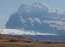
On 14 April 2010 the Volcanic Ash Advisory Centre issued an alert that a volcanic ash cloud was moving from Iceland towards northwestern Europe. It resulted in the sudden closure of large areas of airspace: Scotland’s closed first, then parts of Norway, and the whole of UK airspace the following day. The cloud went on to affect 50% of Europe, and pushed traffic operations down to 30% of normal capacity.
Many airlines believe that the air traffic control authorities overestimated the risk stemming from the volcanic eruption and underestimated the consequences of closing airspace. Around ten million passengers were affected, with almost 80% of flights cancelled at peak times. According to an Oxford Economics study, airlines experienced losses of $2.2bn, while total economic damage reached almost $5bn.
Go deeper with GlobalData

Discover B2B Marketing That Performs
Combine business intelligence and editorial excellence to reach engaged professionals across 36 leading media platforms.
What the aviation industry experienced is what the UK’s National Air Traffic Service spokesperson Patrick Horwood describes as an “unprecedented situation” in air traffic control. “The ash was thrown high into the atmosphere which, coupled with the unusual direction of the winds at the time, brought it squarely into some of the world’s busiest commercial airspace,” he explains.
Regulators were criticised heavily for the shutdown of airspace, particularly by airlines. As UK Civil Aviation Authority chief executive Andrew Haines explains, the industry had “historically avoided tackling the issue of volcanic ash… which would have significantly reduced the impact of the April events”.
Commercial operations therefore followed existing international guidelines to avoid all interaction between jet engines and ash – and crisis management ensued. In the aftermath of the chaos and economic loss, extensive research has been initiated, developments to technology and procedures put in place to avoid such a disaster occurring should a similar situation arise again. So how does the industry plan to react in the future?
Engine ash tolerance
Development work continues in the area of engine ash tolerance , but it is unlikely that any great increase will be achieved in the near future. Although there are solutions to reduce the effects of volcanic ash, it is believed that nothing exists to prevent an engine from ‘flaming out’ if an aircraft flies into a dense cloud of it (computation analysis would show a large accumulation of glass material in the turbine chamber).
Volcanic ash damages machinery and has the potential to cause a failure that would affect all of an aircraft’s propulsion systems at the same time. As the jet engine sucks in large amounts of air, this is a big problem when flying near ash clouds. Consequences can include the erosion and destruction of parts, jams, engine failure and turbine chamber damage or destruction.
However, when making a decision about how to deal with the effects of the ash cloud on the public, regulators were not just dealing with the threat of damaged engines. Ash can affect the aircraft in a variety of different ways. It can ‘blind’ pilots by sandblasting the windscreen and cause damage to the fuselage and aerodynamic surfaces. Ash build up can also block aerodynamic sensors, which can lead to the failure of air speed indicators, and the particles can also disturb radio communication. Air systems can become also become contaminated, creating a smoky odour in the cabin.
Additionally, airlines must take into consideration the economic risk of flying in contaminated zones if they take the decision to fly. Aviation safety standards will demand an increase in maintenance workload due to required inspections to prevent hazardous damage, which could prove to be an unacceptable burden to many.
Airlines’ approach
Some airlines have undertaken independent research and development to better prepare themselves for dealing with concentrations of ash. easyJet is developing an airborne system to conduct a real-time assessment of the levels of ash in an aircraft’s flight path, while British Airways is liaising with the Met Office to consider installing an ash-measuring device on a couple of their aircraft.
In terms of how to better manage the airspace, the Civil Aviation Authority has confirmed its commitment to a more co-ordinated European approach to developing a volcanic ash contingency plan for Europe and the North Atlantic.
To improve operational planning, internationally agreed guidance on how to conduct a risk assessment on a consistent method for making decisions regarding flights in or close to airspace with ash cloud contamination will emerge in the first half of 2011. For Lufthansa, a Europe-wide measuring system is vitally important. The airline firmly believes that air traffic control authorities completely overestimated the risks from the Icelandic eruption and sees the Single European Sky initiative as the way of introducing co-ordination.
The Civil Aviation Authority, however, stands by its approach, claiming that the airspace shutdown was in line with existing guidelines to protect the public – whether they are in aircraft or under flight paths.
In response to claims that operators should have allowed airlines to fly, Haines states: “It would have been unthinkable to abandon the current international guidance without the necessary evidence – when you are dealing with peoples’ lives it is not enough to just make up a less restrictive standard. You have to agree on a new standard based on robust evidence and data.”
New standards and new procedures have been researched and developed since April 2010 – including ash measurement, ash location, charting and operational planning.
Ash measurement
Ian Lisk, volcanic ash programme manager at the UK Met Office, believes that an accurate assessment of the height of the initial eruptive volcanic ash plume is critical for predicting its subsequent movement and dispersion.
Although traditional weather radar technology can provide this information, it is affected by rain, snow and the distance of the radar from the volcano. Because of this, the Met Office has been helping to facilitate a mobile weather radar from Italy.
“The new radar is more suitable for identifying the difference between ash and rain,” says Lisk. “This, coupled with the flexibility to position this radar closer to an erupting volcano, will enable an improved and more detailed assessment of the eruptive volcanic ash plume height.”
In order to also improve predictions concerning the concentration of volcanic ash, the Met Office has placed a contract for the provision of a ‘civil contingency’ aircraft – a twin piston engine Cessna aircraft equipped with specialist instruments and lidar to remotely sense ash.
Further developments by the Met Office include the development of a vehicle that allows a lidar to remotely sense ash while it is moving, allowing the distribution of the ash to be characterised.
“The stationary vehicle will launch conventional radiosondes and aerosol radiosondes observations,” says Lisk. "This technology is being developed by the University of Hertfordshire and the University of Reading, and is due for further testing by the Met Office during 2011.”
Ash location improvements
In order to improve the forecasting of ash trajectory and dispersion the Civil Aviation Authority is working with the International Civil Aviation Organisation and Icelandic authorities to deploy a mobile radar in Iceland. The radar will improve the accuracy and speed of information on the height of any future ash cloud, which will allow officials to measure the amount of ash being produced can be more precisely.
The Met Office and the Civil Aviation Authority are working in partnership on the dispersion model used to predict where the volcanic ash is located. Satellite imagery, lidar, dispersion model development and reviewing of volcanic ash forecast charts are all areas due to be enhanced in the short to medium-term future as a result of ongoing research.
According to the Met Office, its highly sophisticated computer model NAME (used to forecast the movement and dispersion of volcanic ash) will undergo several improvements throughout 2011 – these include refinements to the way that peak and average ash concentrations in vertical layers are calculated and “model assimilation of real-time volcanic ash observational data”.
Charting changes
The model used to assess ash location and density in April 2010 was largely based on the Met Office’s Volcanic Ash Advisory Centre model. Since then, its weaknesses have been discussed – but the problem is largely with the data it uses rather than the model itself. Despite this it was the best model on offer during the crisis period and satellite depictions of ash compared well with the model’s predictions.
“This is one of the key areas where work has continued since ash subsided, but there is still progress to be made,” says Haines.
Processes to improve the accuracy of the Volcanic Ash Advisory Centre charts are in development – for example, data from ground-based lidar should be able to be taken into account by forecasters in the future. Another area undergoing development are the colours used on charts showing low and high-contamination areas of ash, and it is anticipated that these changes will aid the flight planning process.
The Met Office is also working on an analysis of historic eruptions and in-depth climatological studies to better quantify and understand the risks posed by volcanic ash.
“The introduction of new and optimised systems for forecasters will be made in the first half of 2011,” Lisk confirms.
Improved operational planning
A more co-ordinated European approach is being prepared to cope with any future volcanic ash cloud incident, and the Civil Aviation Authority is supporting the development of a volcanic ash contingency plan for Europe and the North Atlantic.
“High-density areas of ash would, in the future, be notified to industry by means of a temporary danger area rather than airspace closure,” says Haines. “This is part of our continuing work to bring operators closer to the decision-making process around ash now that we have all the benefit of more experience and evidence.”
A collaborative approach to operational planning hopes to ensure all aspects of the crisis are better dealt with next time for a more unified and satisfactory outcome.
“Going forwards it is for international and European regulators to build on the short-term solution we put in pace and turn it into a long-term answer,” says Haines. “The international aviation community is better prepared should it be faced again with a situation where flight is only possible through ash.”
